Executive summary
A fast-moving convective storm cell tracked west to east across Islamabad between approximately 12:51 AM and 1:29 AM on 12 July 2026, based on cross-station observations from five WeatherWalay-network stations. The cell moved at an average translation speed of roughly 35 43 km/h and intensified sharply as it reached the Chak Shahzad–Bahria Enclave corridor in the southeast of the city, where it produced severe wind gusts and extreme short-burst rainfall well beyond what any other station recorded. This is consistent with resident reports describing significant localised impact in the Bahria Enclave area.
Station-by-station observations
Onset time marks the first recorded rainfall at each station. Peak wind gust and peak rain rate reflect the single highest one-minute readings recorded during the event window (approximately
12:30 AM–4:30 AM).
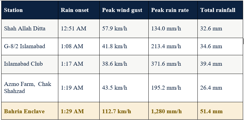
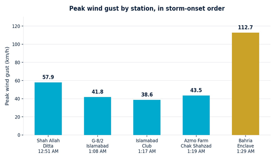
Bahria Enclave (highlighted) recorded the highest readings across every metric nearly triple the next-highest peak wind gust and 3–4x the next-highest peak rain rate.
Peak wind gust by station
Peak rain rate by station
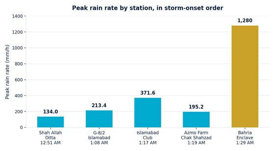
Bahria Enclave's peak rain-rate reading (1,280 mm/h) is an instantaneous one-minute spike, not a sustained hourly rate typical of an intense embedded convective burst but it is still 3–4x higher than the next-highest station on this track.
Storm track and translation speed
Distances and bearings were calculated between consecutive station onset points using station coordinates. The Khanpur Dam station was excluded from this track analysis as it lies well outside the Islamabad urban area, and its early rainfall onset is attributed to a separate feeder band rather
than this storm cell.
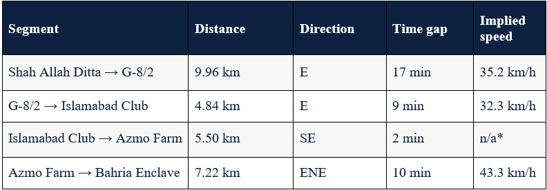
*The Islamabad Club → Azmo Farm segment shows an implausible implied speed because the two stations are only ~5.5 km apart and were struck within 2 minutes of each other likely the storm's leading edge sweeping across both points nearly simultaneously, rather than true segment- to-segment propagation. This value should be disregarded in favor of the overall average.
Storm track map
The cell tracked almost due east (bearing ≈ 95°) from Shah Allah Ditta through central Islamabad, then curved east-northeast into Bahria Enclave, where it reached its most intense phase.
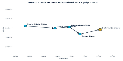
Overall straight-line distance from first onset (Shah Allah Ditta) to last onset (Bahria Enclave) was approximately 25 km, covered in 38 minutes an average translation speed of about 39.4 km/h, consistent with a fast-moving thunderstorm cell (typical range: 20–60 km/h).
Assessments
● Storm type: fast-moving, discrete convective cell (thunderstorm/squall), not a broad steady monsoon band — evidenced by the sharp wind and rain-rate spikes, rapid temperature drops, and short event duration (roughly 90–150 minutes per station) rather than sustained rainfall.
● Track: west to east across Islamabad, curving toward the southeast in its later stages, reaching Bahria Enclave last at 1:29 AM.
● Peak intensity location: Bahria Enclave — gusts of 112.7 km/h and an instantaneous rain- rate spike of 1,280 mm/h, both far exceeding readings at any other station on this track.
● Likely cause of localised impact: the storm reached its most mature and destructive phase (strongest downdraft / gust front) specifically as it crossed the Chak Shahzad–Bahria Enclave corridor, rather than the area simply lying along the track.
● This assessment is consistent with local resident reports describing severe impact in the Bahria Enclave area during the early hours of 12 July 2026.